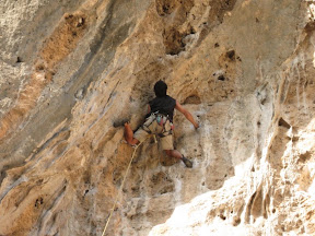
For those who have known me for a while, you will be happy (or distressed) to know that the unsuspecting 'epic' is still alive and well and rearing its head every once in a while.
The plan for my last 'rest day' in Olympos was rather simple - a modestly challenging 25 km hike along the Lycian Way beginning at the next town 18 km away. I would start early and hitch to Andrasan around 7AM and begin hiking early to make it back well before dinner at 7pm. I was told by a few locals that there would be traffic at that time, and it there would be no trouble finding a lift.
Unfortunately, that is not quite how it worked out - I ended up walking the full 18 km along the road to Andrasan without getting a single ride! Originally, I had decided NOT to do the section from Olympos to Andrasan (16km), opting instead for the slightly longer section beyond that (25km), though I now wondered about that option now that my departure was so delayed.
At Andrasan the hike begins at the far end of the beach - another 4 km to the beach, and about 1-2 km more to the far end where the trail starts. I walked out to this section and along the coast for another km or two to at least see that part of the trail I had intended to hike, but decided to return to Andrasan and simply hike the section back to Olympos after all - simultaneously making the logistics of returning in the evening a bit easier.
Asking around, I was able to identify where the trailhead to Olympos started, and found a large park sign in Turkish but with the identifiable word 'Olympos' on it. A clear trail to the right headed along the coast as I expected and I confirmed with a Turkish man nearby that this in fact was the path to Olympos. The trail was very clear - in fact it was essentially a dirt road covered in pine needles, so I wasn't too concerned that the typical 'Lycian Way' markers (red and white striped marks appearing periodically on rocks or trees) were not around - they were hardly necessary.
Things were going quite well until I hit the first fork in the road about 8 km in, with no visible markings anywhere in sight. One of the paths was more clearly trodden so I opted for this one, but was a bit suspicious at this point. A km or so later I encountered another 2 or 3 forks, however. This time, the choice was not so obvious and again no markings were in sight. Luckily at this point a German traveller was coming up behind me on a bike, so I was able to ask him for direction. Imagine my surprise when he told me I couldn't get to Olympos this way - the Lycian way was to the left back at the Andrasan trailhead.
I was now facing a return to Andrasan that would leave me having hiked over 40 km prior to even reaching the start of the trailhead!
Determined not to suffer the hitch back to Olympos, I decided to continue my plan B, and still attempt to return along the trail as long as I was able to find the start by around 2:15, figuring that would give me more than enough time to finish before dark. Arriving back in Andrasan shortly after 2, I scoured the area for the actual trail, heading left at the big sign rather than right, but finding no clear signs after following it for 10 minutes, I had to turn back. Finally, I managed to find a small Lycian Way 'marker' spraypainted faintly on a telephone pole on a road a few metres down from the big sign that I had first noticed. It had a subtle arrow pointing left along the river, so I followed that and eventually found a follow up marker though this new path was far more dubious than the original. It was unbelievable to me that this apparently world class hiking trail was marked so poorly, while a dead end road to a land-locked beach sported a huge sign and a well trodden trail.
Regardless, I followed the 'markers' as well as I could - sometimes not encountering a marker for a few hundred metres, which was alarming when the only apparent trail wandered through farmer's fields and around abandoned tool sheds. I lost the trail numerous times - sometimes reaching an area with no obvious trail, and other times finding 2 or 3 indistinguishable trails going off in different directions. In either case, the marker was often a few hundred metres down one of these paths requiring me to run back and forth searching in frustration. Luckily, there also seemed to be an 'X' painted onto a rock in a few places, which indicated that this was NOT the correct path. This certainly saved my ass a few times and eventually I always did manage to pick up on the trail - but I was losing valuable time. After a couple of hours on this trail I was becoming committed to continuing since it would be dark by the time I returned if I was to turn back now. I figured, however, that once in the forest I would encounter less of the ambiguous trail sections that I typically found when I hit (for example) a labyrinth of unmarked goat paths. Unfortunately, even after a couple of hours, I was still finding small shepherd huts where the trail dimmed substantially.
After 3 hours on the trail (at which point I thought I would be almost done), I was pretty fully committed to continuing, yet I hadn't even reached the high point yet - and the trail was moving up quickly through the forest. Suddenly, I came to an area where there had been a considerable forest fire. All of the trees were either down and half burnt or, if standing, completely charred on the outside. Here I lost the trail entirely, and was unable to pick up on anything resembling a trail further along. In desperation, I clamboured upwards, clawing over the carbon-encrusted logs and branches, hoping a nearby peak would yield me some views that would point me in the right direction. After scrambling through the blackened bush and climbing up periodic outcrops of rock for about half an hour I was well off the trail, and only managed to see further peaks in the distance. Looking around, I could not even tell whether the trail would have headed to the left or right of the main peak in front of me. Desperate to gain height from which to see, in a few places I carefully scaled steep sections of rock 20-30 feet high. While climbing one of these sections, I was about a third of the way up when a large chunk of rock broke off in my hand causing me to essentially hurl a softball-sized rock into my own face. I managed to keep my composure without falling, but only because I had been carefully '3 point climbing' just in case of such an event. It did cause me to reassess my situation and it was looking grim. I was about 3.5 hours up the mountain and it would start getting dark quickly in a little over an hour. Resuming my climb to the top of this peak, I was no further ahead, judging there to be at least two wide saddles - one way off to the left, and one way off to the right. Based on the topography I guessed that the trail would be slightly more likely to ascend to the right, and my only chance of finding the trail would be to go as high up on the ridge as I could and attempt to traverse until I found something resembling the trail. I was having grave doubts by this point, however, and felt I was running (literally) on borrowed time, so I set my alarm and gave myself 15 minutes to find the trail or some obvious sign. At that point, I would have to admit defeat and hightail it back down the mountain as fast as I could, though this would almost certainly still have me scrambling around in the dark for hours. Realistically I felt at this point that I was royally $£!@'ed with darkness imminent and no pending leads. I scampered as quickly as I could and as high as I could, traversing through the burnt forest, my hands and face by this point covered in soot (and a little blood). My goal was to find the saddle and hope that it was localized enough to bring me across a section of the trail. This was presuming of course that the trail did cross the saddle I was heading for, and also that the trail would be better marked at this point than it had been further down the slope. My biggest worry besides missing the trail altogether was of crossing the trail without recognizing it - a definite possibility. With a glimmer of hope remaining, I slid and climbed along the side of the mountain for a final few hundred metres. as my time slowly ran out. With less than a couple of minutes left on my watch, I spotted a saddle with a bit of a clearing and I headed for it, praying for the tell-tale red and white striped marking. Rising to the saddle, I spotted what might be a trail, and with heart pounding followed it for a dozen metres to a rock with a red and white stripe casually marked on it. YES! - Boy was I pumped. Despite having hiked at this point for over 50 km and 11 hours straight with only a 15 minute stop for lunch and my water long gone, I was riding on adrenelin now, and virtually jogged down the remaining trail to attempt to reach Olympos before dark. Luckily the trail on this side of the mountain was well marked and I found very few ambiguous sections. In the end I trotted into the guest house a few minutes after they started serving supper - almost exactly 12 hours later than I had started out that morning.
I believe that this is the longest hike I have ever done in one day with a pack - 58 km in one day ! - (possibly 60 km with all of the backtracking and route finding).
The plan for my last 'rest day' in Olympos was rather simple - a modestly challenging 25 km hike along the Lycian Way beginning at the next town 18 km away. I would start early and hitch to Andrasan around 7AM and begin hiking early to make it back well before dinner at 7pm. I was told by a few locals that there would be traffic at that time, and it there would be no trouble finding a lift.
Unfortunately, that is not quite how it worked out - I ended up walking the full 18 km along the road to Andrasan without getting a single ride! Originally, I had decided NOT to do the section from Olympos to Andrasan (16km), opting instead for the slightly longer section beyond that (25km), though I now wondered about that option now that my departure was so delayed.
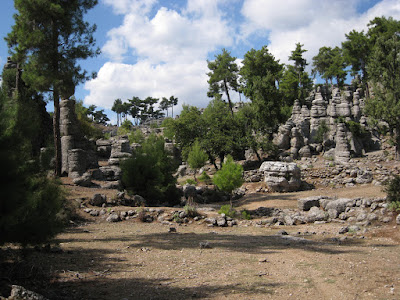
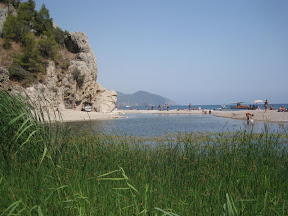
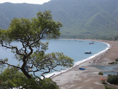 |
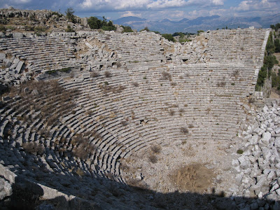
| Andrasan Beach |
At Andrasan the hike begins at the far end of the beach - another 4 km to the beach, and about 1-2 km more to the far end where the trail starts. I walked out to this section and along the coast for another km or two to at least see that part of the trail I had intended to hike, but decided to return to Andrasan and simply hike the section back to Olympos after all - simultaneously making the logistics of returning in the evening a bit easier.
Asking around, I was able to identify where the trailhead to Olympos started, and found a large park sign in Turkish but with the identifiable word 'Olympos' on it. A clear trail to the right headed along the coast as I expected and I confirmed with a Turkish man nearby that this in fact was the path to Olympos. The trail was very clear - in fact it was essentially a dirt road covered in pine needles, so I wasn't too concerned that the typical 'Lycian Way' markers (red and white striped marks appearing periodically on rocks or trees) were not around - they were hardly necessary.
Things were going quite well until I hit the first fork in the road about 8 km in, with no visible markings anywhere in sight. One of the paths was more clearly trodden so I opted for this one, but was a bit suspicious at this point. A km or so later I encountered another 2 or 3 forks, however. This time, the choice was not so obvious and again no markings were in sight. Luckily at this point a German traveller was coming up behind me on a bike, so I was able to ask him for direction. Imagine my surprise when he told me I couldn't get to Olympos this way - the Lycian way was to the left back at the Andrasan trailhead.
I was now facing a return to Andrasan that would leave me having hiked over 40 km prior to even reaching the start of the trailhead!
Determined not to suffer the hitch back to Olympos, I decided to continue my plan B, and still attempt to return along the trail as long as I was able to find the start by around 2:15, figuring that would give me more than enough time to finish before dark. Arriving back in Andrasan shortly after 2, I scoured the area for the actual trail, heading left at the big sign rather than right, but finding no clear signs after following it for 10 minutes, I had to turn back. Finally, I managed to find a small Lycian Way 'marker' spraypainted faintly on a telephone pole on a road a few metres down from the big sign that I had first noticed. It had a subtle arrow pointing left along the river, so I followed that and eventually found a follow up marker though this new path was far more dubious than the original. It was unbelievable to me that this apparently world class hiking trail was marked so poorly, while a dead end road to a land-locked beach sported a huge sign and a well trodden trail.
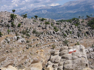
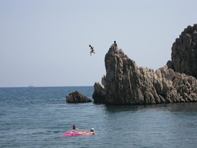
 |
| after my 40 km warmup, I just have to over that distant mountain... |
Regardless, I followed the 'markers' as well as I could - sometimes not encountering a marker for a few hundred metres, which was alarming when the only apparent trail wandered through farmer's fields and around abandoned tool sheds. I lost the trail numerous times - sometimes reaching an area with no obvious trail, and other times finding 2 or 3 indistinguishable trails going off in different directions. In either case, the marker was often a few hundred metres down one of these paths requiring me to run back and forth searching in frustration. Luckily, there also seemed to be an 'X' painted onto a rock in a few places, which indicated that this was NOT the correct path. This certainly saved my ass a few times and eventually I always did manage to pick up on the trail - but I was losing valuable time. After a couple of hours on this trail I was becoming committed to continuing since it would be dark by the time I returned if I was to turn back now. I figured, however, that once in the forest I would encounter less of the ambiguous trail sections that I typically found when I hit (for example) a labyrinth of unmarked goat paths. Unfortunately, even after a couple of hours, I was still finding small shepherd huts where the trail dimmed substantially.
After 3 hours on the trail (at which point I thought I would be almost done), I was pretty fully committed to continuing, yet I hadn't even reached the high point yet - and the trail was moving up quickly through the forest. Suddenly, I came to an area where there had been a considerable forest fire. All of the trees were either down and half burnt or, if standing, completely charred on the outside. Here I lost the trail entirely, and was unable to pick up on anything resembling a trail further along. In desperation, I clamboured upwards, clawing over the carbon-encrusted logs and branches, hoping a nearby peak would yield me some views that would point me in the right direction. After scrambling through the blackened bush and climbing up periodic outcrops of rock for about half an hour I was well off the trail, and only managed to see further peaks in the distance. Looking around, I could not even tell whether the trail would have headed to the left or right of the main peak in front of me. Desperate to gain height from which to see, in a few places I carefully scaled steep sections of rock 20-30 feet high. While climbing one of these sections, I was about a third of the way up when a large chunk of rock broke off in my hand causing me to essentially hurl a softball-sized rock into my own face. I managed to keep my composure without falling, but only because I had been carefully '3 point climbing' just in case of such an event. It did cause me to reassess my situation and it was looking grim. I was about 3.5 hours up the mountain and it would start getting dark quickly in a little over an hour. Resuming my climb to the top of this peak, I was no further ahead, judging there to be at least two wide saddles - one way off to the left, and one way off to the right. Based on the topography I guessed that the trail would be slightly more likely to ascend to the right, and my only chance of finding the trail would be to go as high up on the ridge as I could and attempt to traverse until I found something resembling the trail. I was having grave doubts by this point, however, and felt I was running (literally) on borrowed time, so I set my alarm and gave myself 15 minutes to find the trail or some obvious sign. At that point, I would have to admit defeat and hightail it back down the mountain as fast as I could, though this would almost certainly still have me scrambling around in the dark for hours. Realistically I felt at this point that I was royally $£!@'ed with darkness imminent and no pending leads. I scampered as quickly as I could and as high as I could, traversing through the burnt forest, my hands and face by this point covered in soot (and a little blood). My goal was to find the saddle and hope that it was localized enough to bring me across a section of the trail. This was presuming of course that the trail did cross the saddle I was heading for, and also that the trail would be better marked at this point than it had been further down the slope. My biggest worry besides missing the trail altogether was of crossing the trail without recognizing it - a definite possibility. With a glimmer of hope remaining, I slid and climbed along the side of the mountain for a final few hundred metres. as my time slowly ran out. With less than a couple of minutes left on my watch, I spotted a saddle with a bit of a clearing and I headed for it, praying for the tell-tale red and white striped marking. Rising to the saddle, I spotted what might be a trail, and with heart pounding followed it for a dozen metres to a rock with a red and white stripe casually marked on it. YES! - Boy was I pumped. Despite having hiked at this point for over 50 km and 11 hours straight with only a 15 minute stop for lunch and my water long gone, I was riding on adrenelin now, and virtually jogged down the remaining trail to attempt to reach Olympos before dark. Luckily the trail on this side of the mountain was well marked and I found very few ambiguous sections. In the end I trotted into the guest house a few minutes after they started serving supper - almost exactly 12 hours later than I had started out that morning.
I believe that this is the longest hike I have ever done in one day with a pack - 58 km in one day ! - (possibly 60 km with all of the backtracking and route finding).